When evaluating real estate on the Space Coast, understanding local travel logistics is just as important as the property itself. Buyers moving to the area often prioritize proximity to major aerospace and tech employers.
Navigating daily travel requires a clear picture of the region's infrastructure and typical traffic flow. By looking at current data and completed infrastructure projects in 2026, you can choose a location that balances lifestyle with a manageable daily drive.
The Reality of Commuting in Melbourne, Florida
The layout of Brevard County heavily dictates daily travel patterns for local residents. Because the region is stretched along the coast, most trips require moving north or south before heading east or west.
Currently, about 99% of residents rely on personal vehicles or ride-sharing services for their daily travel. This heavy reliance on cars means that proximity to major thoroughfares significantly impacts your daily schedule. Taking the time to map out your specific route before purchasing a home will save you countless hours over the course of a year.
Average Travel Times and National Comparisons
The average commute time in Melbourne sits comfortably between 22.8 and 26.4 minutes. This timeframe offers a measurable time savings compared to the national average, keeping residents out of gridlock and giving them more time at home.
With typical property values around $380,000, the local homeownership rate holds steady at approximately 57.8%. This indicates established neighborhoods along these primary commuter routes. While morning and evening rush hours do bring increased volume, the delays are generally predictable and localized to specific intersections.
Driving to Major Central Florida Employment Hubs
A large percentage of the local workforce commutes outside the immediate city limits to major economic centers. The Space Coast is home to a sprawling network of defense contractors, aerospace facilities, and regional corporate offices.
Because these hubs are spread out across Central Florida, understanding the primary commuter routes out of the city is essential. Whether you are heading toward the coast or moving inland, your choice of neighborhood will dictate which highway becomes your daily lifeline.
Traveling North to Kennedy Space Center
The commute to Kennedy Space Center spans an approximate 35 to 45-mile distance from most Melbourne neighborhoods. Drivers primarily utilize the I-95 corridor or US-1 to make this northbound trek.
Depending on morning traffic and your specific destination gate, drive times range from 50 to 75 minutes. Reaching the Visitor Complex generally takes less time than navigating to the restricted North End facilities.
Commuting West to Greater Orlando
Traveling westbound to the Orlando metropolitan area involves an approximate 70-mile distance. Commuters typically take US-192 directly west or head north on I-95 to connect with SR-528, known locally as the Beachline Expressway.
You can expect a typical drive of 1 hour and 10 minutes to 1 hour and 30 minutes, heavily dependent on traffic volume. Securing a property near an I-95 interchange in Melbourne can shave crucial minutes off this longer regional commute.
Local Traffic Patterns on Major Arteries
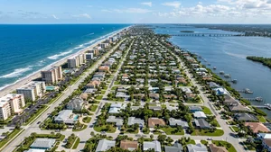
Brevard County features a highly linear road infrastructure that shapes how vehicles move through the region. The geography of the Indian River Lagoon naturally limits east-west travel options, funneling cars onto a few critical causeways.
This geographic constraint means that north-south corridors carry the vast majority of local daily traffic. Understanding the rhythm of these main arteries helps buyers pinpoint neighborhoods that offer the path of least resistance to work and amenities.
Navigating I-95, US-1, and SR-192
I-95 serves as the primary north-south corridor, handling an estimated 90,000 vehicle trips per day locally. For a slower, more scenic alternative running parallel to the water, many residents opt for US-1.
SR-192, also known as New Haven Avenue, operates as the primary east-west local artery connecting the mainland to the barrier islands. Additionally, the Spring 2026 Ellis Road widening project is currently improving traffic flow toward the airport and nearby defense contractor facilities.
Public Transportation Options on the Space Coast
While personal vehicles dominate the roads, there are available non-car transportation networks operating throughout the region. These systems provide critical connections for residents who prefer not to drive or lack access to a personal vehicle.
Overall adoption of these transit alternatives remains low, with fewer than 1% of residents relying exclusively on public transit. However, having access to these routes can be a valuable fallback option or a primary solution for specific commuting needs.
Using the Space Coast Area Transit Network
Local routes within the Space Coast Area Transit network cover major shopping centers, Brevard Public Schools locations, and hospitals. Specific routes, such as 1, 21, 24, and 29, efficiently connect key points of interest across the county.
For those traveling to major employment hubs, the Vanpool Leasing Program assists commuters departing from shared Park & Ride lots. This program effectively mitigates gas and toll costs for groups traveling together. For regional business travel, the Melbourne Orlando International Airport provides highly convenient access right in the center of town.
Frequently Asked Questions
What is the average commute time in Melbourne, FL?
The average commute time for residents sits between 22.8 and 26.4 minutes. This baseline reflects typical local travel and falls below the national average.
What are the public transportation options in Melbourne, FL?
Space Coast Area Transit provides bus routes connecting major shopping centers, schools, and hospitals. Additionally, a Vanpool Leasing Program is available for groups traveling to regional employment hubs.
How long is the commute from Melbourne, FL to Orlando?
Driving from Melbourne to the Orlando metropolitan area takes approximately 1 hour and 10 minutes to 1 hour and 30 minutes. The trip covers roughly 70 miles, typically utilizing US-192 or SR-528.